Garmin
214 watchers
|
Jan 2023
12:37pm, 11 Jan 2023
2,095 posts
|
tipsku
I'm normally just lurking here but your advice with GPS and Glonass may solve my problem of falling into deep holes (100 m or more) during my runs with a FR745. It just occurred to me that trying to process two sets of location data may lead to errors in elevation data. I'll disable Glonass on my next run and report back.
|
|
Jan 2023
3:35pm, 11 Jan 2023
1,743 posts
|
AndyS
tipsku I'd be interested to hear about your results. I had much weirdness with the elevation on my first couple of Fenix 5X a while back - IIRC, Garmin's explanation was that it uses GPS elevation as a "baseline" at the start of an activity, then once it's done that it defers to barometric readings for the remainder. I ended up exchanging the watch 3 (or maybe 4?) times (twice for altitude issues, once or twice for battery issues). The current one seems to have started giving weird altitude readings now (on the upside, it looks like I'm doing a *lot* of ascent :D) |
|
Jan 2023
5:53pm, 11 Jan 2023
15,934 posts
|
Badger
Do you swim with it, Andy? The barometer chips have been known to die from too much chlorinated water (not good bearing in mind these watches have swimming modes). Similar question to Tipsku. Anything with a barometric altimeter should be fairly stable for altitude, they only intermittently calibrate to GPS. When you have more than one constellation enabled, the watch merges the data from the different constellations & uses effectively one satellite's worth of data to manage any clock differences between the constellations. If you can only see one satellite in one of the constellations that would actually be worse than just using the other one, but usually more is better and more also gives better elevation data. |
|
Jan 2023
6:05pm, 11 Jan 2023
18 posts
|
hatstand
While we're on the subject of Garmins (and why wouldn't we be, in a thread called Garmin!), my 245 has been getting very slow on the uptake finding satellites recently. I have plugged it in to Garmin Express which says it's on the latest software (11.60). Watch GPS is set to "GPS & GLONASS." I have no idea what else to check or how to check it, any wisdom gratefully received. I had a similar issue with my 645 last week. One thing I found suggested that the file that caches the satellite locations can get corrupted. You can delete the file to get a new copy but I just did a factory reset which did fix the issue |
|
Jan 2023
6:13pm, 11 Jan 2023
1,745 posts
|
AndyS
The first one gave up the ghost before I'd had a chance to swim with it (it was recording elevation as exactly 20,000m, which was obviously wrong and suggested to me it was a hardware issue being clamped by software). The second one didn't last much longer - it would just swing about wildly. In the intervening few years I've swum with the current one, although not for quite a while, but the barometer shenanigans are relatively recent. So it may be that, or it may be something altogether different.
|
|
Jan 2023
7:01pm, 11 Jan 2023
2,096 posts
|
tipsku
Badger, this is a training entry where Garmin started at the correct altitude, about 560 m, got the first climb to 595 m right and then suddenly plummeted to 466 m when in reality, I only ran down about 15-20 m. 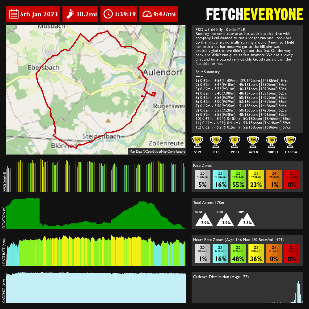 I have no idea what happened, there was no tornado, no thunderstorm nor the eye of a hurricane passing by that would explain a rapid pressure drop like this. A 130 m drop in altitude corresponds to a pressure drop of about 16-17 hPa (rule of the thumb: 1 hPa for every 8 m of elevation). |
|
Jan 2023
7:05pm, 11 Jan 2023
2,097 posts
|
tipsku
For comparison today's training after disabling GLONASS. 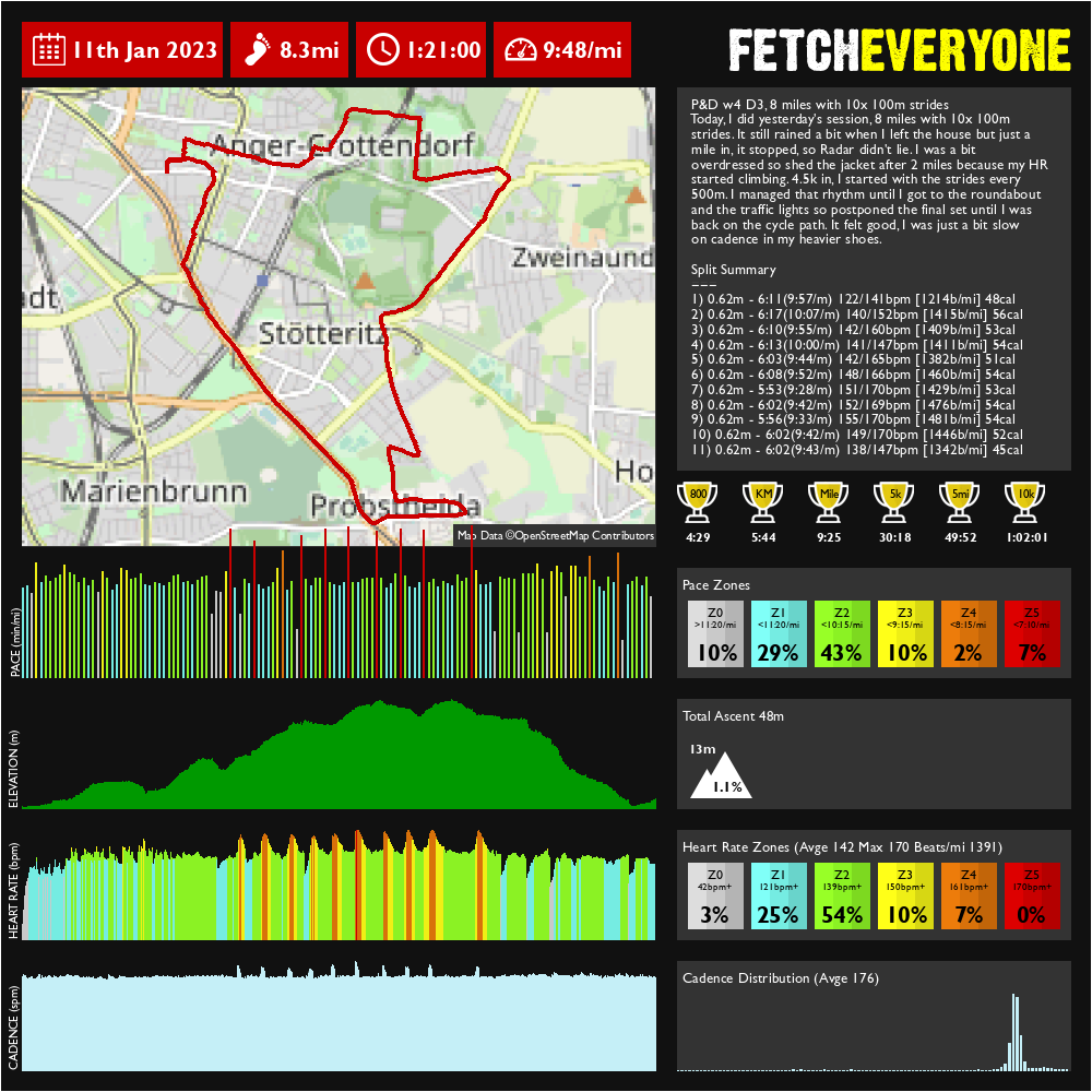 Elevation is fine today. I didn't notice any drop in accuracy, it still followed the paths I was taking went around the bends alright and even registered when I crossed the street. |
|
Jan 2023
7:50pm, 11 Jan 2023
15,935 posts
|
Badger
😲I've never seen anything like that first one tipsku ! Would you be up for trying GPS+Galileo? That's the combination I use and it seems pretty robust (this is on a 6x, though, so it's using mapping for elevation calibration). The Galileo constellation is pretty full now, certainly fine in combination with GPS. AndyS maybe the same suggestion. That first issue you had is the classic dead barometer symptom on a Fenix.
|
|
Jan 2023
8:55pm, 11 Jan 2023
2,098 posts
|
tipsku
I haven't either, Badger, and that was not the only one. I had a few more like that over the past couple of weeks. When I run this course again, I can try the set up GPS plus Galileo and compare it with GPS only today. |
|
Jan 2023
11:39am, 17 Jan 2023
2,557 posts
|
Steve NordRunner
Here's a way to get your Garmin to auto-lap in exact miles, even when otherwise set to kms. The problem: when units are set to km, autolap can only be set in increments of 0,05. The answer: set the system units to miles first, then set auto-lap for your activity to 1 mile, then set system units back to km. Your auto-lap will now be 1,61 km. Could be handy for things like Fetch miles, or when you are a metric person doing a race with mile markers and you are keeping an eye on the marked vs gps distance you have run.
|
Related Threads
-
 Garmin 735xt problem
Jan 2021
Garmin 735xt problem
Jan 2021
-
Garmin and Windows 10
Jun 2016
-
Help pls - what’s latest equiv to garmin vivoactive HR?
Jan 2024
-
Inporting Garmin historic data
Dec 2023
-
Garmin Connect IQ apps and widgets etc
Jan 2023
-
Polar Precision data
Jan 2022
-
PSA - Potential GPS watch stocking filler bargain?
Sep 2021
-
Running Apps Discrepancies
May 2021
-
Are replacement ANT sticks really *that* much?!
Sep 2013
-
SpreadEveryone: The Fetchland Excel wire
Oct 2024