West Highland Way - Milngavie to Rowardennan
- 26.6mi
- Asc 780m
- Hillscore 63
Created by Triplet Dad
This is the "bottom half", i.e. the first 27 miles, of the "Highland Fling" course.
It runs from Milngavie to Rowardennan taking in sections through Mugdock Country Park, via roads, and trails to Drymen, through forest and over Conic Hill to Balmaha, to finish alongside Loch Lomond at Rowardennan.
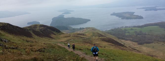
The picture is of runners coming off the back of Conic Hill having reached the summit with Loch Lomond in the distance.

| Hill | Starts At | Ends At | Climb (metres) | Gradient % |
|---|---|---|---|---|
| 1 | 0.0mi | 2.6mi | 66 | 1.6 |
| 2 | 2.9mi | 3.3mi | 21 | 3.1 |
| 3 | 10.7mi | 11.6mi | 40 | 2.7 |
| 4 | 12.0mi | 13.6mi | 116 | 4.3 |
| 5 | 14.3mi | 14.7mi | 17 | 3.4 |
| 6 | 15.2mi | 15.9mi | 33 | 2.8 |
| 7 | 16.0mi | 16.2mi | 17 | 5.1 |
| 8 | 16.7mi | 17.8mi | 168 | 10.0 |
| 9 | 20.6mi | 21.0mi | 11 | 1.6 |
| 10 | 21.3mi | 21.6mi | 24 | 4.7 |
| 11 | 23.2mi | 23.4mi | 27 | 8.0 |
| 12 | 24.2mi | 24.6mi | 63 | 9.4 |
| 13 | 25.4mi | 25.7mi | 16 | 3.2 |
| 14 | 25.9mi | 26.2mi | 15 | 2.9 |

